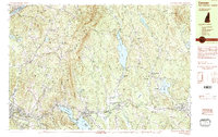
1984 Map of Canaan
USGS Topo · Published 1990About this map
Moose Mountain dominates the center of this landscape, its ridges separating the watershed of the Connecticut River to the west from the lakes and brooks of Canaan to the east. The valley floors show a mix of small settlements and educational infrastructure, notably the Mascoma Valley Regional High Sch situated near West Canaan. In the eastern section, the historic village of Canaan Street overlooks its namesake lake, while the Mascoma State Forest preserves a large tract of woodland north of the Indian River. Transportation patterns here follow the water, with the Boston and Maine RR and Maine Central RR tracking the winding path of the Mascoma River. Notable water bodies including Goose Pond and Crystal Lake define the lowlands, which have long served as local centers for community and industry in Grafton County.
Find a feature on this map
80 named features on this map. Tap any name to fly to it.
Don’t see what you’re looking for? This feature index may not catch every label — zoom into the map to look around manually.
Map Details
Editions of this 1984 Canaan Map
3 editions found
Other maps of this area

1896 · Strafford
USGS Topo · 1:62,500

1906 · Hanover
USGS Topo · 1:62,500

1908 · Hanover
USGS Topo · 1:62,500

1927 · Cardigan
USGS Topo · 1:62,500

1927 · Mascoma
USGS Topo · 1:62,500

1928 · Rumney
USGS Topo · 1:62,500

1930 · Cardigan
USGS Topo · 1:62,500

1931 · Mt. Cube
USGS Topo · 1:62,500

1932 · Mascoma
USGS Topo · 1:62,500

1932 · Rumney
USGS Topo · 1:62,500