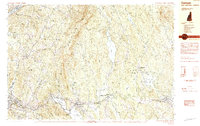
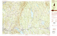
1984 Map of Canaan
USGS Topo · Published 1984About this map
Moose Mountain dominates the center of this New Hampshire landscape, forming a natural divide between the Connecticut River valley and the Mascoma drainage. The settlement pattern in the early 1980s reveals a cluster of distinct villages, from the high plateau of Canaan Street with its historic lakefront to the industrial and transport corridor of the Mascoma River. Along this southern valley, the Boston and Maine railroad line parallels the water, serving towns like Enfield and West Canaan. Cultural and religious history is visible in the naming of Shaker Hill and the Shaker Bridge crossing Mascoma Lake, pointing to the regional influence of the Shaker community. The map also details extensive conservation and recreation areas, including the Mascoma State Forest and the Herbert L Webster Wildlife Management Area, alongside local landmarks like the Mascoma Valley Regional High Sch and Shakoma Beach.
Find a feature on this map
86 named features on this map. Tap any name to fly to it.
Don’t see what you’re looking for? This feature index may not catch every label — zoom into the map to look around manually.
Map Details
Editions of this 1984 Canaan Map
3 editions found

Other maps of this area

1896 · Strafford
USGS Topo · 1:62,500

1906 · Hanover
USGS Topo · 1:62,500

1908 · Hanover
USGS Topo · 1:62,500

1927 · Cardigan
USGS Topo · 1:62,500

1927 · Mascoma
USGS Topo · 1:62,500

1928 · Rumney
USGS Topo · 1:62,500

1930 · Cardigan
USGS Topo · 1:62,500

1931 · Mt. Cube
USGS Topo · 1:62,500

1932 · Mascoma
USGS Topo · 1:62,500

1932 · Rumney
USGS Topo · 1:62,500