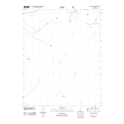
2011 Map of Canaan Peak
USGS Topo · Published 2011About this map
Canaan Peak and Kaiparowitz Peak anchor this high-elevation landscape in Kane County, Utah, where complex drainage networks carve through the high plateaus. The map details a rugged transition from flat basins to sheer vertical features, most notably The Cockscomb, a distinctive geological fold that runs across the southern section. This area is defined by its water sources, with Wahweap Creek and Horse Creek winding through the terrain, alongside isolated reliable points such as Horse Spring and Mud Spring. Historically significant landmarks like Canaan Bottom and Shurtz Bush indicate the traditional ranching and grazing grounds that have long utilized these drainage basins. The intricate contour work illustrates the steep descent into Mud Spring Canyon and the broad, open space of Bull Flat, providing a precise look at the landforms of south-central Utah.
Find a feature on this map
16 named features on this map. Tap any name to fly to it.
Don’t see what you’re looking for? This feature index may not catch every label — zoom into the map to look around manually.
Map Details
Editions of this 2011 Canaan Peak Map
This is the sole edition of this map. No revisions or reprints were ever made.
Other maps of this area

1886 · Escalante
USGS Topo · 1:250,000

1922 · Upper Last Chance
USGS Topo · 1:63,360

1956 · Escalante
USGS Topo · 1:250,000

1960 · Escalante
USGS Topo · 1:250,000

1964 · Canaan Creek
USGS Topo · 1:24,000

1964 · Canaan Peak
USGS Topo · 1:24,000

1964 · Death Ridge
USGS Topo · 1:24,000

1964 · Henrieville
USGS Topo · 1:24,000
1964 · Pine Lake
USGS Topo · 1:24,000
1964 · Butler Valley
USGS Topo · 1:24,000