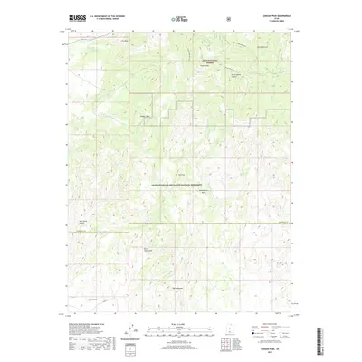
2020 Map of Canaan Peak
USGS Topo · Published 2020About this map
Canaan Peak rises as the central landmark of this high-altitude landscape, where the southern boundary of the Dixie National Forest meets the northern reaches of the Grand Staircase-Escalante National Monument. The terrain is defined by dramatic geological transitions, from the weathered slopes of The Blues in the north to the distinctive formation of The Cockscomb near the southern edge. The map captures an era of conservation and remote management, highlighting the delicate drainage networks of Wahweap Cr and Wiggler Wash.
Find a feature on this map
25 named features on this map. Tap any name to fly to it.
Don’t see what you’re looking for? This feature index may not catch every label — zoom into the map to look around manually.
Map Details
Editions of this 2020 Canaan Peak Map
This is the sole edition of this map. No revisions or reprints were ever made.
Other maps of this area

1886 · Escalante
USGS Topo · 1:250,000

1922 · Upper Last Chance
USGS Topo · 1:63,360

1956 · Escalante
USGS Topo · 1:250,000

1960 · Escalante
USGS Topo · 1:250,000

1964 · Canaan Creek
USGS Topo · 1:24,000

1964 · Canaan Peak
USGS Topo · 1:24,000

1964 · Death Ridge
USGS Topo · 1:24,000

1964 · Henrieville
USGS Topo · 1:24,000
1964 · Pine Lake
USGS Topo · 1:24,000
1964 · Butler Valley
USGS Topo · 1:24,000