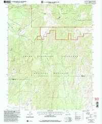
2002 Map of Canaan Peak
USGS Topo · Published 2005About this map
Canaan Peak rises as a prominent landmark in this desert landscape, situated near the boundary where the Dixie National Forest meets the southern reaches of the Grand Staircase - Escalante National Monument. The map documents a complex drainage system characterized by intermittent flows such as Henrieville Creek, Wahweap Creek, and the deeply etched Round Valley Draw. Evidence of the region's geological diversity is found in named features like the striking ridge of The Cockscomb and the pale, eroded badlands of The Blues. High-elevation landmarks such as Canaan Mountain overlook cattle-grazing territory and remote basins like Bull Flat and Headquarters Valley. Transport and access are limited to a few arterial routes, including the Highway 12 corridor, also known as the All American Road, and backcountry paths like the Horse Spring Canyon Loop Trail.
Find a feature on this map
31 named features on this map. Tap any name to fly to it.
Don’t see what you’re looking for? This feature index may not catch every label — zoom into the map to look around manually.
Map Details
Editions of this 2002 Canaan Peak Map
This is the sole edition of this map. No revisions or reprints were ever made.
Other maps of this area

1886 · Escalante
USGS Topo · 1:250,000

1922 · Upper Last Chance
USGS Topo · 1:63,360

1956 · Escalante
USGS Topo · 1:250,000

1960 · Escalante
USGS Topo · 1:250,000

1964 · Canaan Creek
USGS Topo · 1:24,000

1964 · Canaan Peak
USGS Topo · 1:24,000

1964 · Death Ridge
USGS Topo · 1:24,000

1964 · Henrieville
USGS Topo · 1:24,000
1964 · Pine Lake
USGS Topo · 1:24,000
1964 · Butler Valley
USGS Topo · 1:24,000