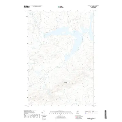
2018 Map of Canada Falls Lake
USGS Topo · Published 2018About this map
Canada Falls Lake dominates this northern Somerset County landscape, where the South Branch Penobscot River feeds into a complex network of wetlands and drainage. The terrain rises sharply to the south at Ironbound Mtn, a prominent peak that overlooks the surrounding timberlands and several small interior basins like Beaver Pond and the Trickey Ponds. This 2018 topographic survey reveals the enduring character of the Maine woods, where movement is dictated by the flow of water and a sparse network of logging routes such as Alder Brook Rd and Cunningham Rd. The hydrography is particularly intricate, including the southern reaches of the S Br Brassua Stream and numerous smaller tributaries like Hale Brook and Fish Brook, reflecting a region primarily defined by its watershed and natural topography rather than permanent settlement.
Find a feature on this map
14 named features on this map. Tap any name to fly to it.
Don’t see what you’re looking for? This feature index may not catch every label — zoom into the map to look around manually.
Map Details
Editions of this 2018 Canada Falls Lake Map
This is the sole edition of this map. No revisions or reprints were ever made.
Other maps of this area

1921 · Brassua Lake
USGS Topo · 1:62,500

1922 · Long Pond
USGS Topo · 1:62,500

1923 · Brassua Lake
USGS Topo · 1:62,500

1924 · Long Pond
USGS Topo · 1:62,500

1944 · Brassua Lake
USGS Topo · 1:62,500

1944 · Long Pond
USGS Topo · 1:62,500

1949 · Jackman
USGS Topo · 1:250,000

1954 · Seboomook Lake
USGS Topo · 1:62,500

1954 · Millinocket
USGS Topo · 1:250,000

1956 · Penobscot Lake
USGS Topo · 1:62,500
Featured Places
- Thorndike Township, ME
- Alder Brook Township, ME
- Pittston Academy Grant, ME
- Hammond Township, ME
- Soldiertown Township, ME