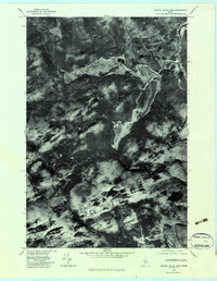
1979 Map of Canada Falls Lake
USGS Topo · Published 1983About this map
Canada Falls Lake dominates this orthophotoquad, which uses aerial photography to capture the intricate hydrography of Somerset County, Maine. The imagery reveals the complex shoreline of the lake and the winding path of the South Branch Penobscot River as it snakes through a heavily forested landscape. The map provides a distinct look at the northern wilderness before the widespread use of digital GIS, showing the natural drainage patterns of tributary systems like Cunningham Brook and Fish Brook. Unlike standard topographic maps, this photographic approach highlights the texture of the forest canopy and the precise reach of the wetlands surrounding Alder Brook and Hale Brook. Researchers can use these visual details to observe the land use and timber management patterns in the Maine North Woods during the late twentieth century.
Find a feature on this map
7 named features on this map. Tap any name to fly to it.
Don’t see what you’re looking for? This feature index may not catch every label — zoom into the map to look around manually.
Map Details
Editions of this 1979 Canada Falls Lake Map
This is the sole edition of this map. No revisions or reprints were ever made.
Other maps of this area

1921 · Brassua Lake
USGS Topo · 1:62,500

1922 · Long Pond
USGS Topo · 1:62,500

1923 · Brassua Lake
USGS Topo · 1:62,500

1924 · Long Pond
USGS Topo · 1:62,500

1944 · Brassua Lake
USGS Topo · 1:62,500

1944 · Long Pond
USGS Topo · 1:62,500

1949 · Jackman
USGS Topo · 1:250,000

1954 · Seboomook Lake
USGS Topo · 1:62,500

1954 · Millinocket
USGS Topo · 1:250,000

1956 · Penobscot Lake
USGS Topo · 1:62,500
Featured Places
- Pittston Academy Grant, ME
- Alder Brook Township, ME
- Hammond Township, ME
- Thorndike Township, ME
- Soldiertown Township, ME