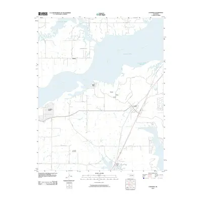
2010 Map of Canadian
USGS Topo · Published 2010About this map
Eufaula Lake dominates the northern landscape of this Oklahoma quadrangle, where the inundated valley of the Canadian River meets its tributaries at Mill Creek and Gibson Creek. The settlement of Canadian serves as a local hub near the eastern shore, while Canadian Shores and Sams Point mark the residential development along the water's edge. In the uplands to the south, Crowder Mountain rises above the Crowder Reservoir Dam, anchoring a landscape defined by a grid of rural roads like Blackberry Rd and Nale Rd. Genealogists will find significant value in the cluster of burial sites south of the lake, including the Masonic Cemetery, Red Oak Cemetery, and McDougal Cemetery, alongside the New Mellette Cemetery further north near the small community of Mellette. This map details a region where modern water management and recreation coexist with older rural heritage and established family landholdings.
Find a feature on this map
25 named features on this map. Tap any name to fly to it.
Don’t see what you’re looking for? This feature index may not catch every label — zoom into the map to look around manually.
Map Details
Editions of this 2010 Canadian Map
This is the sole edition of this map. No revisions or reprints were ever made.
Other maps of this area

1900 · Canadian
USGS Topo · 1:125,000

1946 · Fort Smith
USGS Topo · 1:250,000

1962 · Raiford
USGS Topo · 1:24,000

1963 · Stidham
USGS Topo · 1:24,000

1963 · Eufaula
USGS Topo · 1:24,000

1965 · Fort Smith
USGS Topo · 1:250,000

1967 · Fort Smith
USGS Topo · 1:250,000
1971 · Blocker
USGS Topo · 1:24,000
1971 · Crowder
USGS Topo · 1:24,000
1971 · Canadian
USGS Topo · 1:24,000