
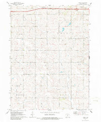
1971 Map of Canby
USGS Topo · Published 1973About this map
Canby sits at the center of this Adair County landscape, where the rural sections of Summit, Walnut, Eureka, and Prussia townships converge. This 1971 survey captures the region's agricultural character, defined by a network of section-line roads and several established burial grounds including St Josephs Cem and Oakwood Cem in the north and Prussia Cem in the south. The drainage of the Middle Nodaway River and Ninemile Creek carves across the terrain, reflecting the natural geography that dictated local land use for generations. Institutional life is marked by the Highland Ch, while modern infrastructure appears at the top of the sheet with the Sewage Disposal Ponds and a highway Rest Area, signaling the influence of regional transit on this traditionally quiet farming community.
Find a feature on this map
15 named features on this map. Tap any name to fly to it.
Don’t see what you’re looking for? This feature index may not catch every label — zoom into the map to look around manually.
Map Details
Editions of this 1971 Canby Map
2 editions found
Other maps of this area

1952 · Panora
USGS Topo · 1:62,500

1954 · Greenfield
USGS Topo · 1:62,500

1954 · Omaha
USGS Topo · 1:250,000

1957 · Omaha
USGS Topo · 1:250,000

1958 · Omaha
USGS Topo · 1:250,000

1971 · Adair South
USGS Topo · 1:24,000

1971 · Fontanelle
USGS Topo · 1:24,000

1971 · Casey
USGS Topo · 1:24,000

1971 · Fontanelle SW
USGS Topo · 1:24,000
1971 · Adair North
USGS Topo · 1:24,000