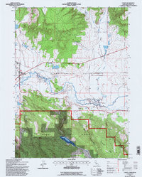
1993 Map of Canby
USGS Topo · Published 1997About this map
The Pit River meanders through the heart of Warm Springs Valley, where agricultural water management is evidenced by an extensive network of levees and weirs. The town of Canby sits at the junction of Route 299 and the river, serving as a hub near the edge of the Devils Garden plateau. Significant local landmarks include Kelley Hot Spring and a nearby Historical Monument, along with the Arlington Ch and a local Cem.
Find a feature on this map
24 named features on this map. Tap any name to fly to it.
Don’t see what you’re looking for? This feature index may not catch every label — zoom into the map to look around manually.
Map Details
Editions of this 1993 Canby Map
This is the sole edition of this map. No revisions or reprints were ever made.
Other maps of this area

1886 · Alturas
USGS Topo · 1:250,000

1892 · Alturas
USGS Topo · 1:250,000

1954 · Alturas
USGS Topo · 1:250,000

1958 · Alturas
USGS Topo · 1:250,000

1961 · Canby
USGS Topo · 1:62,500

1961 · Alturas
USGS Topo · 1:62,500

1962 · Alturas
USGS Topo · 1:250,000

1962 · Big Sage Reservoir
USGS Topo · 1:62,500

1962 · Jacks Butte
USGS Topo · 1:62,500

1965 · Alturas
USGS Topo · 1:250,000