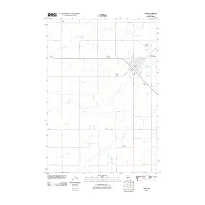
2010 Map of Canby
USGS Topo · Published 2010About this map
The city of Canby serves as the primary hub of this agricultural region in Yellow Medicine County, positioned at the intersection of a well-defined grid of section roads and regional thoroughfares like County Hwy-19. The landscape is defined by the winding courses of Lazarus Creek and Canby Creek, which drain toward the Lac qui Parle River in the southeast. For local historians and genealogists, the map is particularly rich in burial sites, documenting Saint Peters Cemetery, Saint Pauls Cemetery, Saint Stephens Cemetery, Trinity Cemetery, and Swenson Cemetery across the prairie. The presence of the Canby Lake Dam and the Canby Municipal Airport reflects the developed infrastructure supporting this rural community. To the northwest, the small settlement of Burr marks another point of historical interest along the 240th Avenue corridor, illustrating the dispersed but organized settlement pattern of the western Minnesota plains.
Find a feature on this map
34 named features on this map. Tap any name to fly to it.
Don’t see what you’re looking for? This feature index may not catch every label — zoom into the map to look around manually.
Map Details
Editions of this 2010 Canby Map
This is the sole edition of this map. No revisions or reprints were ever made.
Other maps of this area

1953 · Watertown
USGS Topo · 1:250,000

1958 · Watertown
USGS Topo · 1:250,000

1967 · Canby
USGS Topo · 1:24,000

1967 · Dawson SW
USGS Topo · 1:24,000

1967 · Gary
USGS Topo · 1:24,000

1967 · Canby NW
USGS Topo · 1:24,000

1967 · Porter
USGS Topo · 1:24,000
1967 · Porter SW
USGS Topo · 1:24,000

1967 · Gary SE
USGS Topo · 1:24,000

1967 · Canby SE
USGS Topo · 1:24,000