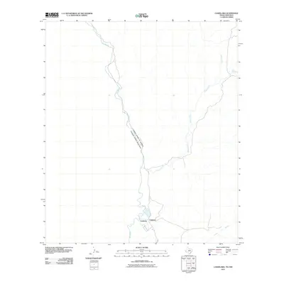
2010 Map of Candelaria
USGS Topo · Published 2010About this map
Candelaria sits at the edge of the Chihuahuan Desert along the international boundary, a remote settlement at the terminus of Fm 170. This 2010 survey illustrates the village's close relationship with the Rio Grande, which separates the United States from Mexico. The map details the drainage patterns of the region, specifically where Capote Creek and the Arroyo Palo Blanco meet the river valley. The presence of the label Cadelaria adjacent to the primary townsite suggests a localized variant or secondary naming convention for the settlement during this era. As a late-modern topographic record, the map shows the sparse infrastructure of Presidio County, defined primarily by the river's path and the winding course of Walker Creek to the north.
Find a feature on this map
8 named features on this map. Tap any name to fly to it.
Don’t see what you’re looking for? This feature index may not catch every label — zoom into the map to look around manually.
Map Details
Editions of this 2010 Candelaria Map
This is the sole edition of this map. No revisions or reprints were ever made.
Other maps of this area

1896 · San Carlos
USGS Topo · 1:125,000

1959 · Marfa
USGS Topo · 1:250,000

1965 · Marfa
USGS Topo · 1:250,000
1978 · Capote Peak
USGS Topo · 1:24,000

1979 · Ruidosa Hot Springs
USGS Topo · 1:24,000

1979 · Capote Falls
USGS Topo · 1:24,000
1979 · Candelaria
USGS Topo · 1:24,000
1979 · McCutchen Ranch
USGS Topo · 1:24,000
1979 · Pueblo Nuevo
USGS Topo · 1:24,000
1979 · McComb Canyon
USGS Topo · 1:24,000