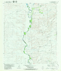
1979 Map of Pueblo Nuevo
USGS Topo · Published 1980About this map
The Rio Grande serves as the central artery and international border in this 1970s survey of the Trans-Pecos region, where the water's path dictates the placement of small agricultural settlements and ranching outposts. Along the river's winding course, local history is preserved at Pueblo Nuevo, La Oficina, and La Macolla. The landscape is defined by its drainages, including the Arroyo Palo Blanco and Naegele Creek, which cut through the high desert terrain. Notable cultural markers such as a Cementerio and the Hot Springs area reflect the human presence in this arid environment. This edition captures the borderlands just as the International Boundary and Water Commission formally established the line between Presidio County and Chihuahua, providing a specific record of the land use near Mesa Ojo Caliente and the Navarrette area.
Find a feature on this map
40 named features on this map. Tap any name to fly to it.
Don’t see what you’re looking for? This feature index may not catch every label — zoom into the map to look around manually.
Map Details
Editions of this 1979 Pueblo Nuevo Map
2 editions found
Other maps of this area

1896 · Ruidosa
USGS Topo · 1:125,000

1896 · San Carlos
USGS Topo · 1:125,000

1959 · Presidio
USGS Topo · 1:250,000

1959 · Marfa
USGS Topo · 1:250,000

1965 · Presidio
USGS Topo · 1:250,000

1965 · Marfa
USGS Topo · 1:250,000

1978 · Sierra Parda
USGS Topo · 1:24,000

1979 · Ruidosa Hot Springs
USGS Topo · 1:24,000

1979 · Capote Falls
USGS Topo · 1:24,000
1979 · Candelaria
USGS Topo · 1:24,000