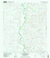
1979 Map of Pueblo Nuevo
USGS Topo · Published 1980About this map
The Rio Bravo Del Norte Rio Grande carves through this desert landscape along the border between Presidio County and Chihuahua, Mexico. Compiled in the late 1970s, this survey documents a network of arid canyons and seasonal watercourses, including Arroyo Palo Blanco and Arroyo Santana, that define the local drainage patterns. Small rural outposts such as Pueblo Nuevo and La Oficina are situated among the higher elevations, while a Jeep Trail provides the primary transit through the rugged terrain. Local aviation and infrastructure are represented by the Hot Springs Airport and a nearby Drill Hole. Genealogists may find interest in the scattered Cementerio and Cem sites that mark the presence of family settlements like La Rata and La Macolla along the river's winding path.
Find a feature on this map
40 named features on this map. Tap any name to fly to it.
Don’t see what you’re looking for? This feature index may not catch every label — zoom into the map to look around manually.
Map Details
Editions of this 1979 Pueblo Nuevo Map
2 editions found
Other maps of this area

1896 · Ruidosa
USGS Topo · 1:125,000

1896 · San Carlos
USGS Topo · 1:125,000

1959 · Presidio
USGS Topo · 1:250,000

1959 · Marfa
USGS Topo · 1:250,000

1965 · Presidio
USGS Topo · 1:250,000

1965 · Marfa
USGS Topo · 1:250,000

1978 · Sierra Parda
USGS Topo · 1:24,000

1979 · Ruidosa Hot Springs
USGS Topo · 1:24,000

1979 · Capote Falls
USGS Topo · 1:24,000
1979 · Candelaria
USGS Topo · 1:24,000