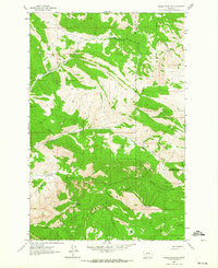
1962 Map of Candle Mountain
USGS Topo · Published 1964About this map
Helena National Forest lands dominate this 1962 field-checked survey of the mountainous divide between Lewis and Clark and Cascade counties. The landscape is defined by the prominent peaks of Candle Mountain and Willow Mountain, with a drainage system including Cottonwood Creek and Willow Creek flowing through the high country. The absence of paved infrastructure is notable, with the terrain instead navigated by a network of Jeep Trails and Pack Trails, such as the route following Elkhorn Creek. This cartography emphasizes the area's role as a managed wilderness and resource zone rather than a site of permanent settlement, though the presence of the Nelson Ranch just six miles away indicates the proximity of regional livestock operations. Steep canyons like Meriwether Canyon and numerous named drainages such as Hunters Gulch and Slip Gulch illustrate the complex topography of the Montana backcountry during the early 1960s.
Find a feature on this map
17 named features on this map. Tap any name to fly to it.
Don’t see what you’re looking for? This feature index may not catch every label — zoom into the map to look around manually.
Map Details
Editions of this 1962 Candle Mountain Map
This is the sole edition of this map. No revisions or reprints were ever made.
Other maps of this area

1886 · Great Falls
USGS Topo · 1:250,000

1886 · Fort Logan
USGS Topo · 1:250,000

1948 · White Sulphur Springs
USGS Topo · 1:250,000

1954 · Great Falls
USGS Topo · 1:250,000

1957 · Great Falls
USGS Topo · 1:250,000

1958 · White Sulphur Springs
USGS Topo · 1:250,000

1961 · White Sulphur Springs
USGS Topo · 1:250,000

1961 · Craig
USGS Topo · 1:24,000

1961 · Hound Creek Reservoir
USGS Topo · 1:24,000
1961 · The Sawteeth
USGS Topo · 1:24,000