1961 Map of Craig
USGS Topo · Published 1964About this map
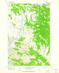
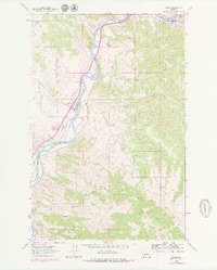
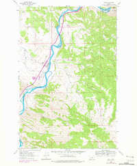
Craig sits at the heart of this mid-century survey, positioned where the Great Northern railroad tracks trace the winding path of the Missouri River. The landscape is defined by the heavy drainage patterns of Dog Creek and Stickney Creek, which feed into the river valley from the surrounding high ground. Local landmarks such as Brewer Hill and the Wolf Creek Airway Beacon on the western ridges reflect the area's importance for both terrestrial and aerial navigation during this era. The map records a complex network of canyons and draws including Bray Gulch, Acres Gulch, and Log Gulch, which segment the terrain south of the main settlement. Small-scale infrastructure like the Radio Tower and Sevenmile Road underscore the sparse but deliberate development of the Lewis and Clark Co backcountry.
Find a feature on this map
19 named features on this map. Tap any name to fly to it.
Don’t see what you’re looking for? This feature index may not catch every label — zoom into the map to look around manually.
Map Details
Editions of this 1961 Craig Map
3 editions found
Other maps of this area

1886 · Great Falls
USGS Topo · 1:250,000

1886 · Fort Logan
USGS Topo · 1:250,000

1889 · Helena
USGS Topo · 1:250,000

1893 · Helena
USGS Topo · 1:250,000

1899 · Helena
USGS Topo · 1:250,000

1903 · Helena
USGS Topo · 1:250,000

1943 · Hogan
USGS Topo · 1:125,000

1947 · Butte
USGS Topo · 1:250,000

1948 · White Sulphur Springs
USGS Topo · 1:250,000

1954 · Great Falls
USGS Topo · 1:250,000