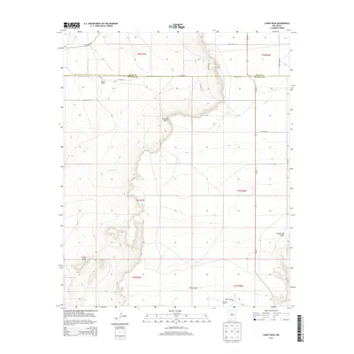
2013 Map of Candy Mesa
USGS Topo · Published 2013About this map
Candy Mesa and the surrounding high plains of De Baca and Quay Counties reveal a landscape defined by sharp escarpments and isolated ranching operations. The terrain is marked by prominent landforms such as Charlotte Point and the sprawling Taiban Mesa, where the flat tabletop heights drop away into drainage systems like Cottonwood Canyon. Water is a critical but scarce resource in this region, traced by the intermittent flows of Red Tank Cr and Truchas Cr. Settlement is sparse and focused on working lands, centered on the Knighten Ranch in the northwest and M and M Ranch to the south. The transition between the high mesa and the lower plains is navigated by a network of rural routes including House Cap Rd and Long Canyon Rd, while NM-252 serves as the primary north-south artery through this open cattle country.
Find a feature on this map
28 named features on this map. Tap any name to fly to it.
Don’t see what you’re looking for? This feature index may not catch every label — zoom into the map to look around manually.
Map Details
Editions of this 2013 Candy Mesa Map
This is the sole edition of this map. No revisions or reprints were ever made.
Other maps of this area

1954 · Fort Sumner
USGS Topo · 1:250,000

1954 · Clovis
USGS Topo · 1:250,000

1958 · Fort Sumner
USGS Topo · 1:250,000

1958 · Clovis
USGS Topo · 1:250,000

1968 · Hassell
USGS Topo · 1:24,000

1968 · Twin Mesa NW
USGS Topo · 1:24,000

1968 · Fort Sumner East
USGS Topo · 1:24,000

1968 · Candy Mesa
USGS Topo · 1:24,000

1968 · Taiban
USGS Topo · 1:24,000

1968 · Twin Mesa
USGS Topo · 1:24,000