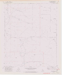
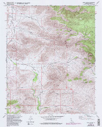
1972 Map of Cane Canyon
USGS Topo · Published 1976About this map
Kelso Valley serves as the central corridor for this 1972 survey of the high desert and mountain terrain where the southern Sierras meet the Mojave landscape. The topography is defined by the Scodie Mountains and the boundary of the Sequoia National Forest, revealing a network of remote water sources essential for livestock and local travel. Named springs like Yellow Jacket Spring and Shoemaker Spring dot the arid canyons, while scattered cemeteries and wells such as Cholla Well and Cane Well mark the sparse human footprint. For researchers of the Kern County interior, the map provides a clear look at the early 1970s infrastructure, showing a transition from improved roads to extensive pack trails and jeep trails that reach landmarks like Skinner Peak and Wyleys Knob. The presence of several mines and prospects along the canyon walls reflects the persistent search for mineral wealth in these elevations.
Find a feature on this map
34 named features on this map. Tap any name to fly to it.
Don’t see what you’re looking for? This feature index may not catch every label — zoom into the map to look around manually.
Map Details
Editions of this 1972 Cane Canyon Map
5 editions found
Other maps of this area

1906 · Kernville
USGS Topo · 1:125,000

1908 · Kernville
USGS Topo · 1:125,000

1915 · Mojave
USGS Topo · 1:125,000

1943 · Cross Mountain
USGS Topo · 1:62,500

1943 · Emerald Mtn
USGS Topo · 1:62,500

1943 · Onyx
USGS Topo · 1:62,500

1943 · Isabella
USGS Topo · 1:62,500

1948 · Bakersfield
USGS Topo · 1:250,000

1955 · Bakersfield
USGS Topo · 1:250,000

1956 · Bakersfield
USGS Topo · 1:250,000