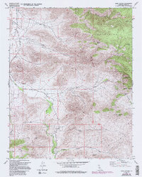
1972 Map of Cane Canyon
USGS Topo · Published 1994About this map
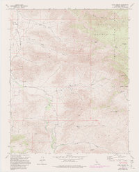
The Scodie Mountains and the arid expanse of Kelso Valley dominate this terrain on the eastern edge of the Sequoia National Forest. Mapped in the early 1970s and revised in the 1990s, the landscape reflects a sparse high-desert settlement pattern focused on water sources and transportation. A small Cem and an isolated Landing Strip near the Kelso Valley Road mark the human footprint in an area otherwise defined by steep canyons and seasonal drainage systems. Named water features like Cane Well and Pinyon Well suggest the vital importance of reliable water for ranching or travel through this corridor. For the historian or researcher, the map preserves the location of several remote mining efforts, indicated by labels for Prospect and Mine, alongside geographic landmarks like Kelso Peak and the passage through Bird Spring Pass.
Find a feature on this map
34 named features on this map. Tap any name to fly to it.
Don’t see what you’re looking for? This feature index may not catch every label — zoom into the map to look around manually.
Map Details
Editions of this 1972 Cane Canyon Map
5 editions found
Other maps of this area

1906 · Kernville
USGS Topo · 1:125,000

1908 · Kernville
USGS Topo · 1:125,000

1915 · Mojave
USGS Topo · 1:125,000

1943 · Cross Mountain
USGS Topo · 1:62,500

1943 · Emerald Mtn
USGS Topo · 1:62,500

1943 · Onyx
USGS Topo · 1:62,500

1943 · Isabella
USGS Topo · 1:62,500

1948 · Bakersfield
USGS Topo · 1:250,000

1955 · Bakersfield
USGS Topo · 1:250,000

1956 · Bakersfield
USGS Topo · 1:250,000