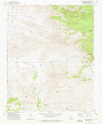
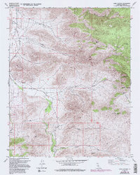
1972 Map of Cane Canyon
USGS Topo · Published 1976About this map
The high-desert terrain of the Scodie Mountains and the arid expanse of Kelso Valley dominate this landscape during the early 1970s. This region of Kern County exhibits a pattern of survival and resource extraction, where water sources like Cholla Well, Cane Well, and Pinyon Well served as critical points for travelers and livestock. Small Cem markers and unnamed Mine and Prospect sites suggest a history of prospecting and ranching that persisted long after the initial California booms.
Find a feature on this map
36 named features on this map. Tap any name to fly to it.
Don’t see what you’re looking for? This feature index may not catch every label — zoom into the map to look around manually.
Map Details
Editions of this 1972 Cane Canyon Map
5 editions found
Other maps of this area

1906 · Kernville
USGS Topo · 1:125,000

1908 · Kernville
USGS Topo · 1:125,000

1915 · Mojave
USGS Topo · 1:125,000

1943 · Cross Mountain
USGS Topo · 1:62,500

1943 · Emerald Mtn
USGS Topo · 1:62,500

1943 · Onyx
USGS Topo · 1:62,500

1943 · Isabella
USGS Topo · 1:62,500

1948 · Bakersfield
USGS Topo · 1:250,000

1955 · Bakersfield
USGS Topo · 1:250,000

1956 · Bakersfield
USGS Topo · 1:250,000