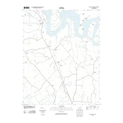
2010 Map of Cane Valley
USGS Topo · Published 2010About this map
The Green River Hill Confederate Cemetery stands as a notable landmark in this region of Adair County, reflecting the deep Civil War history embedded in the Kentucky landscape. To the north, the waters of Green River Lake dominate the geography, characterized by distinct features like Buffalo Cliff and Fisher Bend. This 2010 survey illustrates a rural infrastructure centered around the crossroads of Coburg, Kellyville, and Cane Valley, where agricultural patterns follow the drainage of Russell Creek and Caney Fork. For genealogists, the map is remarkably detailed with family-named landmarks and burial grounds, including the Faulkner Cemetery, Griffin Cemetery, and Hutchison Cemetery. The network of local roads, such as Buck Watson Rd and Steve Breeding Rd, provides a precise guide to the family settlements and land divisions of the early 21st century.
Find a feature on this map
68 named features on this map. Tap any name to fly to it.
Don’t see what you’re looking for? This feature index may not catch every label — zoom into the map to look around manually.
Map Details
Editions of this 2010 Cane Valley Map
This is the sole edition of this map. No revisions or reprints were ever made.
Other maps of this area

1952 · Mannsville
USGS Topo · 1:24,000

1953 · Gradyville
USGS Topo · 1:24,000

1953 · Campbellsville
USGS Topo · 1:24,000

1953 · Montpelier
USGS Topo · 1:24,000

1953 · Gresham
USGS Topo · 1:24,000

1953 · Cane Valley
USGS Topo · 1:24,000

1954 · Knifley
USGS Topo · 1:24,000

1954 · Columbia
USGS Topo · 1:24,000

1954 · Greensburg
USGS Topo · 1:24,000

1957 · Winchester
USGS Topo · 1:250,000