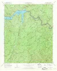
1967 Map of Caney Creek
USGS Topo · Published 1970About this map
Ocoee River industrial and recreational life is documented in this late 1960s study, featuring the infrastructure of the Ocoee Power Plant No 2 and the adjacent Parksville Lake (Ocoee Lake). The landscape is defined by the steep ridges of the Cherokee National Forest, including Hogback Mountain and Big Frog Mtn. Civil engineering of the era is evident through the gaging station, cable crossing, and a complex flume and tramway system along the riverbanks.
Find a feature on this map
114 named features on this map. Tap any name to fly to it.
Don’t see what you’re looking for? This feature index may not catch every label — zoom into the map to look around manually.
Map Details
Editions of this 1967 Caney Creek Map
2 editions found
Other maps of this area

1886 · Dalton
USGS Topo · 1:125,000

1886 · Cleveland
USGS Topo · 1:125,000

1888 · Ellijay
USGS Topo · 1:125,000

1892 · Cleveland
USGS Topo · 1:125,000

1892 · Ellijay
USGS Topo · 1:125,000

1892 · Dalton
USGS Topo · 1:125,000

1893 · Murphy
USGS Topo · 1:125,000

1895 · Cleveland
USGS Topo · 1:125,000

1897 · Dalton
USGS Topo · 1:125,000

1898 · Ellijay
USGS Topo · 1:125,000