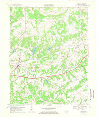
1967 Map of Caneyville
USGS Topo · Published 1969About this map
Caneyville serves as the focal point of this western Grayson County landscape, situated at the crossroads of the Western Kentucky Toll Road Parkway and the Illinois Central Railroad. The town's proximity to Caney Creek and its series of reservoirs, including the Caneyville Reservoir and Lake No 1, defines the local water management and recreation patterns of the late 1960s. The topography is characterized by many knobs and hills, such as Pine Knob and Hoover Hill, which dictated the winding paths of rural routes like Morgantown Road and Leitchfield Road.
Find a feature on this map
43 named features on this map. Tap any name to fly to it.
Don’t see what you’re looking for? This feature index may not catch every label — zoom into the map to look around manually.
Map Details
Editions of this 1967 Caneyville Map
This is the sole edition of this map. No revisions or reprints were ever made.
Other maps of this area

1922 · Leitchfield
USGS Topo · 1:48,000

1925 · Spring Lick
USGS Topo · 1:62,500

1925 · Leitchfield
USGS Topo · 1:62,500

1932 · Fordsville
USGS Topo · 1:62,500

1953 · Mc Daniels
USGS Topo · 1:24,000

1953 · Ready
USGS Topo · 1:24,000

1953 · Bee Spring
USGS Topo · 1:24,000

1953 · Falls Of Rough
USGS Topo · 1:24,000

1954 · Evansville
USGS Topo · 1:250,000

1954 · Spring Lick
USGS Topo · 1:24,000