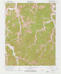
1965 Map of Cannel City
USGS Topo · Published 1977About this map
Cannel City serves as a focal point for this 1960s study of the Morgan and Wolfe County borderlands, where the landscape is defined by the winding drainages of Caney Creek and its many forks. The map documents a rural economy still marked by extractive industry, with scattered Oil Wells and a Gas Well appearing alongside the small settlements of Nickell and Daysboro. For the local historian, the mapping of dual-identity places like Salem and Adele provides critical evidence of the era's evolving postal and community geography.
Find a feature on this map
69 named features on this map. Tap any name to fly to it.
Don’t see what you’re looking for? This feature index may not catch every label — zoom into the map to look around manually.
Map Details
Editions of this 1965 Cannel City Map
3 editions found
Other maps of this area

1889 · Salyersville
USGS Topo · 1:125,000

1891 · Salyersville
USGS Topo · 1:125,000

1899 · Salyersville
USGS Topo · 1:125,000

1950 · Lenox
USGS Topo · 1:24,000

1951 · Cannel City
USGS Topo · 1:24,000

1951 · Landsaw
USGS Topo · 1:24,000

1951 · White Oak
USGS Topo · 1:24,000

1951 · Ezel
USGS Topo · 1:24,000

1951 · Hazel Green
USGS Topo · 1:24,000
1951 · Lenox
USGS Topo · 1:24,000