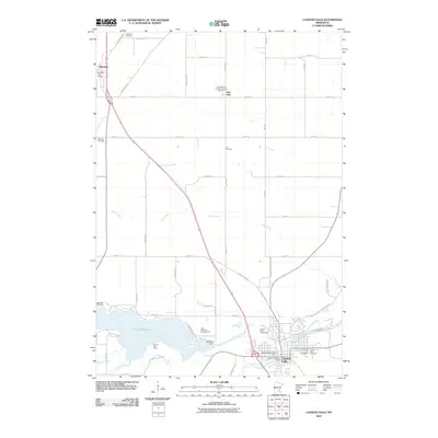
2010 Map of Cannon Falls
USGS Topo · Published 2010About this map
Cannon River waters dominate the southern portion of this Goodhue County landscape, controlled by the Byllesby Dam which forms the expansive Lake Byllesby. This 2010 survey illustrates a primarily agricultural region punctuated by established rural settlements like Hampton and New Trier, where Saint Mary's Catholic Church and its associated Saint Mary's Catholic Church Cemetery serve as local landmarks. The area's history is deeply etched into its numerous burial grounds, including Lakeside Cemetery on the lake's western edge and Zion Cemetery further north. In the town of Cannon Falls, the confluence of the Little Cannon River and the main branch creates a hub of activity near the Cannon Valley Fairgrounds. Regional connectivity is defined by established routes such as Rochester Blvd and the Cannon Valley Trl, which follow the natural contours of the river valley.
Find a feature on this map
56 named features on this map. Tap any name to fly to it.
Don’t see what you’re looking for? This feature index may not catch every label — zoom into the map to look around manually.
Map Details
Editions of this 2010 Cannon Falls Map
This is the sole edition of this map. No revisions or reprints were ever made.
Other maps of this area

1953 · Saint Paul
USGS Topo · 1:250,000

1957 · Farmington
USGS Topo · 1:62,500

1957 · Hastings
USGS Topo · 1:62,500

1959 · Saint Paul
USGS Topo · 1:250,000

1960 · Dennison
USGS Topo · 1:24,000

1968 · Sogn
USGS Topo · 1:24,000

1968 · White Rock
USGS Topo · 1:24,000
1974 · Coates
USGS Topo · 1:24,000
1974 · Randolph
USGS Topo · 1:24,000
1974 · Cannon Falls
USGS Topo · 1:24,000