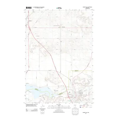
2013 Map of Cannon Falls
USGS Topo · Published 2013About this map
Cannon Falls sits at the confluence of the Cannon River and Little Cannon River, serving as a focal point for this landscape along the border of Dakota and Goodhue counties. The area is characterized by the expansive Lake Byllesby, a significant reservoir formed by the damming of the Cannon River. To the northwest, the small settlements of Hampton and New Trier are connected by a network of rural routes including Rochester Blvd and Hogan Ave.
Find a feature on this map
69 named features on this map. Tap any name to fly to it.
Don’t see what you’re looking for? This feature index may not catch every label — zoom into the map to look around manually.
Map Details
Editions of this 2013 Cannon Falls Map
This is the sole edition of this map. No revisions or reprints were ever made.
Other maps of this area

1953 · Saint Paul
USGS Topo · 1:250,000

1957 · Farmington
USGS Topo · 1:62,500

1957 · Hastings
USGS Topo · 1:62,500

1959 · Saint Paul
USGS Topo · 1:250,000

1960 · Dennison
USGS Topo · 1:24,000

1968 · Sogn
USGS Topo · 1:24,000

1968 · White Rock
USGS Topo · 1:24,000
1974 · Coates
USGS Topo · 1:24,000
1974 · Randolph
USGS Topo · 1:24,000
1974 · Cannon Falls
USGS Topo · 1:24,000