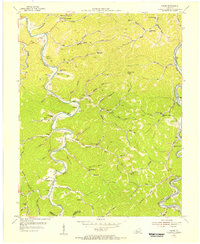
1954 Map of Canoe
USGS Topo · Published 1956About this map
The Middle Fork Kentucky River snakes through the center of this 1954 landscape, flanked by numerous family cemeteries and remote mountain settlements. Rural centers like Crockettsville and Talbert are linked by winding roads that follow the contours of the deeply dissected Cumberland Plateau. The map reveals a high density of local institutions, including the Beech Grove Ch and the Mill Creek Ch, alongside a surprising number of small rural schools such as Arrowood Sch and Raleigh Sch. To the southeast, the North Fork Kentucky River and the Louisville and Nashville railroad provide a critical transportation corridor near Altro. Elevated landmarks like the Nailors Rock Lookout Tower underscore the region's vertical relief and forested character. This survey preserves the locations of numerous post offices, such as Juan PO and Beech PO, reflecting the isolated nature of these communities before modern infrastructure transformation.
Find a feature on this map
89 named features on this map. Tap any name to fly to it.
Don’t see what you’re looking for? This feature index may not catch every label — zoom into the map to look around manually.
Map Details
Editions of this 1954 Canoe Map
This is the sole edition of this map. No revisions or reprints were ever made.
Other maps of this area

1889 · Salyersville
USGS Topo · 1:125,000

1891 · Manchester
USGS Topo · 1:125,000

1891 · Hazard
USGS Topo · 1:125,000

1891 · Salyersville
USGS Topo · 1:125,000

1892 · Beattyville
USGS Topo · 1:125,000

1899 · Salyersville
USGS Topo · 1:125,000

1913 · Buckhorn
USGS Topo · 1:62,500

1951 · Quicksand
USGS Topo · 1:24,000

1951 · Jackson
USGS Topo · 1:24,000

1952 · Tallega
USGS Topo · 1:24,000