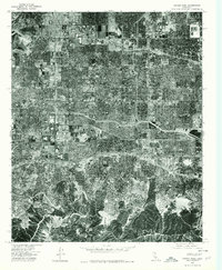
1976 Map of Canoga Park
USGS Topo · Published 1980About this map
Northridge and Canoga Park sit at the heart of the San Fernando Valley during the mid-1970s, a period of dense suburban consolidation within the city limits of Los Angeles. This orthophotoquad, derived from aerial photography taken in June 1976, provides a literal overhead perspective of the residential grids, major arterial roads, and the expanding reach of neighborhoods like Woodland Hills and Encino. The imagery reveals a sharp contrast between the highly organized urban development in the valley floor and the dramatic, undeveloped topographic relief of the hills to the south. Researchers can observe the mid-century layout of commercial corridors and the maturation of these specific Valley communities just before the major population shifts of the following decades. The map was produced by the U.S. Geological Survey in cooperation with the Forest Service, capturing the landscape exactly as it appeared on the nation's bicentennial.
Find a feature on this map
5 named features on this map. Tap any name to fly to it.
Don’t see what you’re looking for? This feature index may not catch every label — zoom into the map to look around manually.
Map Details
Editions of this 1976 Canoga Park Map
2 editions found
Other maps of this area

1894 · Los Angeles
USGS Topo · 1:62,500

1896 · Santa Monica
USGS Topo · 1:62,500

1898 · Santa Monica
USGS Topo · 1:62,500

1900 · Los Angeles
USGS Topo · 1:62,500

1900 · Fernando
USGS Topo · 1:62,500

1901 · Southern California Sheet No. 1
USGS Topo · 1:250,000

1902 · Santa Monica
USGS Topo · 1:62,500

1903 · Calabasas
USGS Topo · 1:62,500

1903 · Camulos
USGS Topo · 1:125,000

1903 · Santa Susana
USGS Topo · 1:62,500