
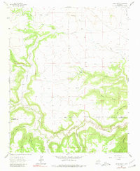
1964 Map of Canon Ancho
USGS Topo · Published 1966About this map
The Mora River carves a deep path through the southern reaches of this landscape, marking the boundary between Mora Co and San Miguel Co. The terrain is defined by a network of steep canyons and drainage systems, most notably the massive Cañon Ancho and its secondary branches like Cañon Escondido and Middle Canyon. Human settlement is sparse and tied to these watercourses, evidenced by the Paltenghe Ranch and isolated cemeteries that speak to the ranching history of the region.
Find a feature on this map
28 named features on this map. Tap any name to fly to it.
Don’t see what you’re looking for? This feature index may not catch every label — zoom into the map to look around manually.
Map Details
Editions of this 1964 Canon Ancho Map
2 editions found
Other maps of this area

1892 · Watrous
USGS Topo · 1:125,000

1894 · Watrous
USGS Topo · 1:125,000

1954 · Santa Fe
USGS Topo · 1:250,000

1958 · Santa Fe
USGS Topo · 1:250,000

1964 · Frutosa Lake
USGS Topo · 1:24,000

1964 · Mogote Hills
USGS Topo · 1:24,000

1964 · Alamosa Creek
USGS Topo · 1:24,000

1971 · Alamito
USGS Topo · 1:24,000

1971 · Canon Las Cuevas
USGS Topo · 1:24,000
1972 · Maes
USGS Topo · 1:24,000