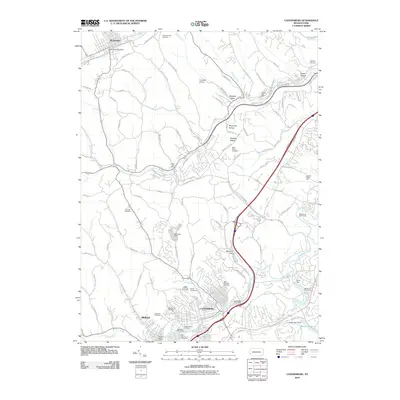
2010 Map of Canonsburg
USGS Topo · Published 2010About this map
Canonsburg sits at the heart of this Washington County landscape, where the winding course of Chartiers Creek meets a dense network of suburban development and historical sites. The area is notable for its concentration of memorial grounds, ranging from Saint Michaels Cemetery and the Polish Cemetery near the town center to the outlying Bethany Cemetery. This pattern of multiple small cemeteries suggests a community built upon distinct ethnic and religious neighborhood foundations.
Find a feature on this map
104 named features on this map. Tap any name to fly to it.
Don’t see what you’re looking for? This feature index may not catch every label — zoom into the map to look around manually.
Map Details
Editions of this 2010 Canonsburg Map
This is the sole edition of this map. No revisions or reprints were ever made.
Other maps of this area

1901 · Amity
USGS Topo · 1:62,500

1904 · Amity
USGS Topo · 1:62,500

1904 · Carnegie
USGS Topo · 1:62,500

1904 · Burgettstown
USGS Topo · 1:62,500

1906 · Burgettstown
USGS Topo · 1:62,500

1906 · Carnegie
USGS Topo · 1:62,500

1907 · Claysville
USGS Topo · 1:62,500

1908 · Carnegie
USGS Topo · 1:62,500
1948 · Pittsburgh West
USGS Topo · 1:24,000
1951 · Pittsburgh West
USGS Topo · 1:24,000