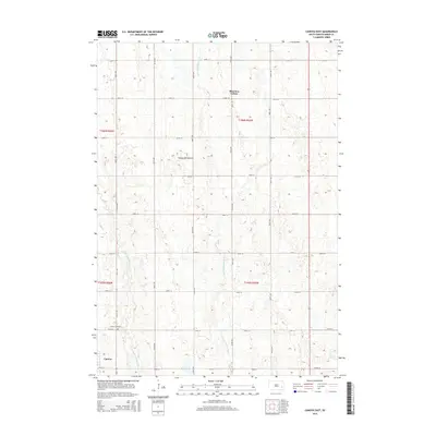
2015 Map of Canova East
USGS Topo · Published 2015About this map
Canova sits at the southwestern corner of this survey, marking a localized pocket of settlement within the expansive agricultural grid of eastern South Dakota. The landscape is defined by the subtle rise of the Coteau des Prairies, a vast plateau that shapes the regional drainage. Waterways like the Little Vermillion River and the W Fork Vermillion River cut through the terrain, tracing paths between sections of farmland. In the northern reaches, Shannon Colony represents a distinct community hub amidst the structured township lines. For those researching local history, the Canova Cemetery remains a clear landmark on the outskirts of town, while the meticulous layout of roads like 241st St and 436th Ave reflects the enduring Public Land Survey System structure that has governed this prairie region for over a century.
Find a feature on this map
25 named features on this map. Tap any name to fly to it.
Don’t see what you’re looking for? This feature index may not catch every label — zoom into the map to look around manually.
Map Details
Editions of this 2015 Canova East Map
This is the sole edition of this map. No revisions or reprints were ever made.
Other maps of this area

1899 · Alexandria
USGS Topo · 1:125,000

1899 · De Smet
USGS Topo · 1:125,000

1953 · Watertown
USGS Topo · 1:250,000

1955 · Sioux Falls
USGS Topo · 1:250,000

1958 · Sioux Falls
USGS Topo · 1:250,000

1958 · Watertown
USGS Topo · 1:250,000

1968 · Oldham SW
USGS Topo · 1:24,000

1968 · Oldham SE
USGS Topo · 1:24,000

1971 · Howard
USGS Topo · 1:24,000
1971 · Winfred
USGS Topo · 1:24,000