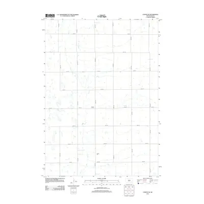
2012 Map of Canova SE
USGS Topo · Published 2012About this map
Wolf Cr meanders south through this corner of Hanson County, defining the drainage patterns of a landscape segmented by a precise section-line road grid. The map reveals a strictly rural township structure where transportation is dictated by numeric routes such as 430th Ave and 247th St. Small family and community landmarks are the primary indicators of historical settlement, specifically Pleasant Hill Cem and Hillside Cem, which sit atop the subtle rises in the prairie terrain. This 2012 survey illustrates the enduring nature of the American agrarian grid, where the placement of these cemeteries relative to the creeks and section lines provides a reliable reference for genealogists tracing local land ownership and ancestral locations in the South Dakota plains.
Find a feature on this map
17 named features on this map. Tap any name to fly to it.
Don’t see what you’re looking for? This feature index may not catch every label — zoom into the map to look around manually.
Map Details
Editions of this 2012 Canova SE Map
This is the sole edition of this map. No revisions or reprints were ever made.
Other maps of this area

1899 · Alexandria
USGS Topo · 1:125,000

1955 · Sioux Falls
USGS Topo · 1:250,000

1958 · Sioux Falls
USGS Topo · 1:250,000

1964 · Salem
USGS Topo · 1:24,000
1971 · Canova East
USGS Topo · 1:24,000

1971 · Unityville
USGS Topo · 1:24,000

1973 · Farmer
USGS Topo · 1:24,000

1973 · Canova SE
USGS Topo · 1:24,000
1973 · Spencer
USGS Topo · 1:24,000
1973 · Bitter Lake
USGS Topo · 1:24,000
Featured Places
- Edgerton Township, SD
- Rock Creek Township, SD
- Pearl Township, SD
- Spring Lake Township, SD
- Benton Township, SD