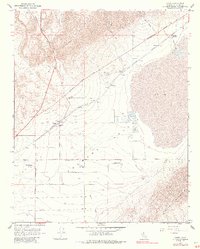
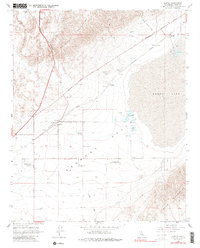
1967 Map of Cantil
USGS Topo · Published 1987About this map
The arid floor of Fremont Valley and the surrounding El Paso Mountains define this landscape during the mid-1960s. The map illustrates a specialized industrial and transportation corridor where the Southern Pacific railroad served mineral extraction sites along the edge of the dry Koehn Lake bed. Key nodes of this economy include the Saltdale settlement with its associated Salt Evaporators and the now-deteriorated Daley Mill. To the west, Red Rock Canyon cuts through the mountains near the former Ricardo site, while the interior valley features small settlements like Cantil and Gypsite. This document provides a look at the desert's infrastructure, from the early Historical Monument to functional features like a Landing Strip and named desert routes including Munsey Road and Last Chance Canyon Road.
Find a feature on this map
31 named features on this map. Tap any name to fly to it.
Don’t see what you’re looking for? This feature index may not catch every label — zoom into the map to look around manually.
Map Details
Editions of this 1967 Cantil Map
5 editions found
Other maps of this area

1915 · Searles Lake
USGS Topo · 1:250,000

1915 · Mojave
USGS Topo · 1:125,000

1943 · Cross Mountain
USGS Topo · 1:62,500

1943 · Saltdale
USGS Topo · 1:62,500

1943 · Castle Butte
USGS Topo · 1:62,500

1943 · Mojave
USGS Topo · 1:62,500

1947 · Castle Butte
USGS Topo · 1:50,000

1947 · Trona
USGS Topo · 1:250,000

1948 · Trona
USGS Topo · 1:250,000

1948 · Bakersfield
USGS Topo · 1:250,000