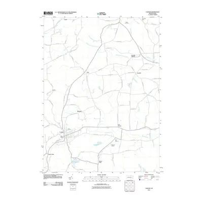
2010 Map of Canton
USGS Topo · Published 2010About this map
Canton serves as the central hub for this portion of Bradford County, where the valley floor of Towanda Creek meets the rising slopes of Alba Mountain. This modern 2010 survey illustrates a landscape of established rural settlements and agricultural corridors, with many roads still bearing family names like Kelley Rd and McMurray Rd. The area's character is defined by its small villages and rural hamlets, including Alba, Minnequa, and East Canton, often centered around natural water sources like Mill Creek and Beech Flats Creek. Local history is anchored by several burial grounds, including Park Cemetery and Saint Michaels Cemetery near the main town center, and Beech Flats Cemetery to the east. Recreational features like Lake Nephawin and the Lambs Hill Picnic Area reflect the community's use of the local terrain, while the Sugar Creek Dam at the northern edge points to modern water management in the Sugar Creek watershed.
Find a feature on this map
86 named features on this map. Tap any name to fly to it.
Don’t see what you’re looking for? This feature index may not catch every label — zoom into the map to look around manually.
Map Details
Editions of this 2010 Canton Map
This is the sole edition of this map. No revisions or reprints were ever made.
Other maps of this area

1931 · Troy
USGS Topo · 1:48,000

1938 · Troy
USGS Topo · 1:62,500

1939 · Sayre
USGS Topo · 1:62,500

1942 · Sayre
USGS Topo · 1:62,500

1942 · Canton
USGS Topo · 1:62,500

1943 · Powell
USGS Topo · 1:62,500

1944 · Canton
USGS Topo · 1:62,500

1945 · Powell
USGS Topo · 1:62,500

1948 · Sayre
USGS Topo · 1:62,500

1953 · Roseville
USGS Topo · 1:24,000