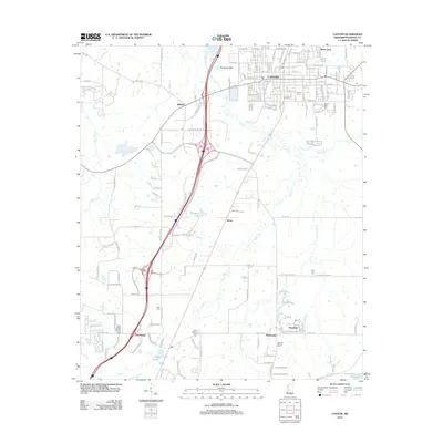
2012 Map of Canton
USGS Topo · Published 2012About this map
Canton serves as the focal point of this Madison County region, showing a dense grid of established streets including W Peace St and E Fulton St alongside various community landmarks. Significant for genealogical research, the map identifies several burial sites and religious centers, such as Canton Cem, Saint Joseph Catholic Church, and the New Mount Zion Cem. The landscape is defined by its transition from the urban center of the county seat to outlying communities like Gluckstadt, Maris Town, and Meltonville. Water features such as Ragsdale Lake, Patton Lake, and the upper reaches of the Ross R Barnett Reservoir indicate the local drainage into Bear Creek and Panther Creek. The transportation network reveals the modern footprint of major thoroughfares intersecting with historic routes like Old Yazoo City Rd, illustrating the expansion of residential and industrial areas southward from the historic core.
Find a feature on this map
161 named features on this map. Tap any name to fly to it.
Don’t see what you’re looking for? This feature index may not catch every label — zoom into the map to look around manually.
Map Details
Editions of this 2012 Canton Map
This is the sole edition of this map. No revisions or reprints were ever made.
Other maps of this area

1903 · Jackson
USGS Topo · 1:125,000

1905 · Jackson
USGS Topo · 1:48,000

1908 · Jackson
USGS Topo · 1:62,500

1922 · Pelahatchee
USGS Topo · 1:48,000

1924 · Pelahatchee
USGS Topo · 1:62,500

1950 · Pelahatchie
USGS Topo · 1:62,500

1952 · Pelahatchie
USGS Topo · 1:62,500

1953 · Meridian
USGS Topo · 1:250,000

1955 · Jackson
USGS Topo · 1:250,000

1957 · Meridian
USGS Topo · 1:250,000