
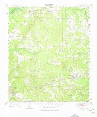
1950 Map of Pelahatchie
USGS Topo · Published 1968About this map
The Choctaw Treaty Line of 1820 cuts diagonally across the northeastern corner of this Rankin County landscape, marking a significant historical boundary in central Mississippi. The terrain is a mix of wooded hills and open meadows like Barnes Prairie and Rollison Prairie, where rural life is anchored by small communities such as Goshen Springs, Fannin, and Leesburg. The southern portion of the map is defined by the Illinois Central Railroad corridor, connecting the regional center of Brandon with Pelahatchie. This rail link, supported by the Brandon Depot, facilitated the movement of goods and people during the mid-20th century. Numerous country schools and churches, including Andrews Chapel and St Helens Ch, are scattered throughout the countryside, reflecting the established social fabric of the era. The presence of the Pearl River and its many tributaries, like Pelahatchie Creek and Clear Creek, underscores the importance of water resources to the region's agricultural and settlement patterns.
Find a feature on this map
90 named features on this map. Tap any name to fly to it.
Don’t see what you’re looking for? This feature index may not catch every label — zoom into the map to look around manually.
Map Details
Editions of this 1950 Pelahatchie Map
2 editions found
Other maps of this area

1903 · Jackson
USGS Topo · 1:125,000

1905 · Jackson
USGS Topo · 1:48,000

1906 · Florence
USGS Topo · 1:62,500

1908 · Jackson
USGS Topo · 1:62,500

1908 · Florence
USGS Topo · 1:62,500

1922 · Morton
USGS Topo · 1:48,000

1922 · Pelahatchee
USGS Topo · 1:48,000

1924 · Pelahatchee
USGS Topo · 1:62,500

1924 · Morton
USGS Topo · 1:62,500

1951 · Morton
USGS Topo · 1:62,500