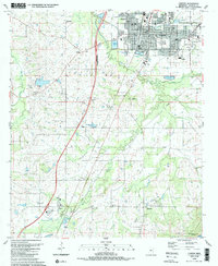
1989 Map of Canton
USGS Topo · Published 1989About this map
Canton serves as the focal point of this Mississippi landscape, revealing a well-established infrastructure of schools and civic institutions. Educational history is particularly prominent, with sites ranging from the Canton Academy and Canton High Sch to the legacy of the Old Madison Ch and Sch further west. The surrounding countryside is dotted with small rural communities like Ballard, Sloan, and Deerfield, each anchored by local landmarks such as Harvey Chapel and Buckhorn Ch.
Find a feature on this map
42 named features on this map. Tap any name to fly to it.
Don’t see what you’re looking for? This feature index may not catch every label — zoom into the map to look around manually.
Map Details
Editions of this 1989 Canton Map
This is the sole edition of this map. No revisions or reprints were ever made.
Other maps of this area

1903 · Jackson
USGS Topo · 1:125,000

1905 · Jackson
USGS Topo · 1:48,000

1908 · Jackson
USGS Topo · 1:62,500

1922 · Pelahatchee
USGS Topo · 1:48,000

1924 · Pelahatchee
USGS Topo · 1:62,500

1950 · Pelahatchie
USGS Topo · 1:62,500

1952 · Pelahatchie
USGS Topo · 1:62,500

1953 · Meridian
USGS Topo · 1:250,000

1955 · Jackson
USGS Topo · 1:250,000

1957 · Meridian
USGS Topo · 1:250,000