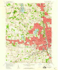
1958 Map of Canton West
USGS Topo · Published 1960About this map
Industrial and residential expansion characterizes the western periphery of Canton in the late 1950s, where urban growth meets the water-rich landscape of Jackson and Perry townships. Significant local landmarks such as Meyers Lake and Sippo Lake serve as focal points for recreation and development, while the extensive campus of the McKinley Memorial Park and the Brunnerdale Seminary anchor the educational and civic landscape. The map captures a dense network of essential institutions, including Aultman Hospital and Mercy Hospital, alongside numerous parochial schools like St Josephs Sch and Sacred Heart Sch. The transportation infrastructure is dominated by the Pennsylvania RR and major thoroughfares like Lincoln Way, reflecting a period of post-war suburbanization as residential areas like Avondale and Whipple Heights begin to fill the spaces between the industrial hearts of Massillon and Canton.
Find a feature on this map
99 named features on this map. Tap any name to fly to it.
Don’t see what you’re looking for? This feature index may not catch every label — zoom into the map to look around manually.
Map Details
Editions of this 1958 Canton West Map
This is the sole edition of this map. No revisions or reprints were ever made.
Other maps of this area

1901 · Massillon
USGS Topo · 1:62,500

1901 · Canton
USGS Topo · 1:62,500

1903 · Massillon
USGS Topo · 1:62,500

1903 · Canton
USGS Topo · 1:62,500

1912 · Dover
USGS Topo · 1:62,500

1914 · Navarre
USGS Topo · 1:62,500

1944 · Navarre
USGS Topo · 1:62,500

1944 · Dover
USGS Topo · 1:62,500

1951 · Canton
USGS Topo · 1:250,000

1951 · Bolivar
USGS Topo · 1:24,000