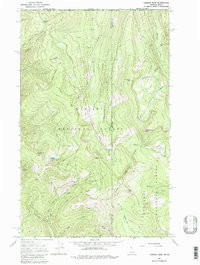
1965 Map of Canuck Peak
USGS Topo · Published 1979About this map
Canuck Peak and the surrounding high country of the Kaniksu National Forest and Kootenai National Forest define this borderland landscape in the mid-1960s. The survey illustrates a region shaped by high-elevation topography and early resource exploration, marked by scattered prospects and a Borrow Pit. A network of specialized transport routes, including the Copper Road, Copper Connection Road, and various Pack Trails, provides a record of how this remote terrain was navigated before modern infrastructure. This map is particularly notable for capturing the precise intersection of the Canada-United States boundary with the state lines of Idaho and Montana, showcasing how international and state borders traverse peaks like American Mtn and waterways such as American Creek. High alpine basins are dotted with small water bodies including Copper Lake and Spruce Lake, which sit tucked beneath ridges like Ruby Ridge.
Find a feature on this map
44 named features on this map. Tap any name to fly to it.
Don’t see what you’re looking for? This feature index may not catch every label — zoom into the map to look around manually.
Map Details
Editions of this 1965 Canuck Peak Map
2 editions found
Other maps of this area

1911 · Priest Lake
USGS Topo · 1:250,000

1913 · Priest Lake
USGS Topo · 1:250,000

1957 · Kalispell
USGS Topo · 1:250,000

1958 · Sandpoint
USGS Topo · 1:250,000

1960 · Kalispell
USGS Topo · 1:250,000

1961 · Kalispell
USGS Topo · 1:250,000

1963 · Sandpoint
USGS Topo · 1:250,000

1963 · Mount Baldy
USGS Topo · 1:24,000

1963 · Northwest Peak
USGS Topo · 1:24,000

1965 · Meadow Creek
USGS Topo · 1:24,000