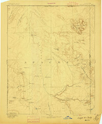
1892 Map of Canyon De Chelly
USGS Topo · Published 1897About this map
Canyon De Chelly and Canyon Del Muerto dominate the lower half of this reconnaissance survey, revealing the complex drainage and mesa system of northeastern Apache County. This mapping effort, directed by J.W. Powell and topographically surveyed by H.M. Wilson, documents a landscape defined by seasonal water sources and isolated landforms before modern road networks arrived. The Chinlee Valley runs north-to-south, flanked by the Carriso Mts, Lukachukai Mts, and Tunitcha Mountains. Numerous springs, such as Saeliso Springs and Hospitito Spring, serve as vital landmarks across the arid expanse. The map also delineates the Navajo Indian Res. Line and the Arizona Boundary Line, noting distinctive geological features like The Captains and Pastora Peak that served as primary navigation points for travelers in the late nineteenth century.
Find a feature on this map
49 named features on this map. Tap any name to fly to it.
Don’t see what you’re looking for? This feature index may not catch every label — zoom into the map to look around manually.
Map Details
Editions of this 1892 Canyon De Chelly Map
5 editions found

Other maps of this area

1883 · Marsh Pass
USGS Topo · 1:250,000

1883 · Tusayan
USGS Topo · 1:250,000

1886 · Wingate
USGS Topo · 1:250,000

1886 · Tusayan
USGS Topo · 1:250,000

1886 · Fort Defiance
USGS Topo · 1:250,000

1886 · Henry Mountains
USGS Topo · 1:250,000

1886 · Abajo
USGS Topo · 1:250,000

1889 · Chaco
USGS Topo · 1:250,000

1892 · Fort Defiance
USGS Topo · 1:250,000

1892 · Marsh Pass
USGS Topo · 1:250,000