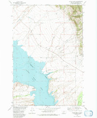
1972 Map of Canyon Ferry SE
USGS Topo · Published 1975About this map
Canyon Ferry Lake dominates this 1972 survey, revealing the shoreline of the reservoir along the Missouri River in Broadwater County. The map details a landscape transition where the water meets the steep eastern terrain of the Helena National Forest. Small settlements like Geary and Don appear alongside recreation and transit markers, including the White Earth Campground and a remote Landing Strip near Goose Bay.
Find a feature on this map
23 named features on this map. Tap any name to fly to it.
Don’t see what you’re looking for? This feature index may not catch every label — zoom into the map to look around manually.
Map Details
Editions of this 1972 Canyon Ferry SE Map
This is the sole edition of this map. No revisions or reprints were ever made.
Other maps of this area

1886 · Fort Logan
USGS Topo · 1:250,000

1948 · White Sulphur Springs
USGS Topo · 1:250,000

1950 · Canyon Ferry
USGS Topo · 1:62,500

1950 · Townsend
USGS Topo · 1:62,500

1950 · Duck Creek Pass
USGS Topo · 1:62,500

1958 · White Sulphur Springs
USGS Topo · 1:250,000

1961 · White Sulphur Springs
USGS Topo · 1:250,000

1965 · White Sulphur Springs
USGS Topo · 1:250,000

1966 · Diamond City
USGS Topo · 1:24,000

1966 · Whites City
USGS Topo · 1:24,000