
1966 Map of Whites City
USGS Topo · Published 1970About this map
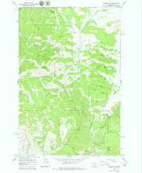
Helena National Forest dominates this mid-1960s survey, documenting a rugged landscape of the Big Belt Mountains where Broadwater and Meagher counties meet. The settlement of Whites City sits in the lower terrain, surrounded by a complex network of gulches that reveal the area's mining and ranching legacy. Evidence of prospecting is scattered throughout the drainages, notably at the Humming Bird Mine and Schabert Mine, as well as numerous unnamed Mines and Prospects in the high country. The map traces a topography defined by steep ridges like Needham Mountain and Bilk Mountain, intersected by seasonal drainages such as Ready Cash Gulch and Cement Gulch. This period records the backcountry access routes of the era, including the Little Bridge Trail and various unimproved dirt roads that follow the winding paths of Beaver Creek and White Creek.
Find a feature on this map
44 named features on this map. Tap any name to fly to it.
Don’t see what you’re looking for? This feature index may not catch every label — zoom into the map to look around manually.
Map Details
Editions of this 1966 Whites City Map
2 editions found
Other maps of this area

1886 · Fort Logan
USGS Topo · 1:250,000

1948 · White Sulphur Springs
USGS Topo · 1:250,000

1950 · Canyon Ferry
USGS Topo · 1:62,500

1958 · White Sulphur Springs
USGS Topo · 1:250,000

1961 · White Sulphur Springs
USGS Topo · 1:250,000

1962 · Snedaker Basin
USGS Topo · 1:24,000

1965 · White Sulphur Springs
USGS Topo · 1:250,000

1966 · Boulder Baldy
USGS Topo · 1:24,000

1966 · Diamond City
USGS Topo · 1:24,000

1966 · Lingshire
USGS Topo · 1:24,000