
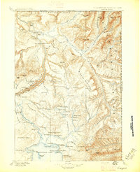
1896 Map of Canyon
USGS Topo · Published 1896About this map
The northern reaches of Yellowstone National Park appear in meticulous detail following the 1884-5 field surveys by Frank Tweedy. This landscape is defined by its hydrothermal activity and dramatic relief, featuring numerous thermal landmarks such as Calcite Springs, Joseph Coat Springs, and the Mud Geysers near the Lamar River. The map captures the park before widespread infrastructure, noting early visitor accommodations like the Hotel on the northern shore of Yellowstone Lake and the outpost at Yanceys near the junction of the Yellowstone River and Tower Creek.
Find a feature on this map
122 named features on this map. Tap any name to fly to it.
Don’t see what you’re looking for? This feature index may not catch every label — zoom into the map to look around manually.
Map Details
Editions of this 1896 Canyon Map
2 editions found
Other maps of this area

1885 · Lake
USGS Topo · 1:125,000

1885 · Gallatin
USGS Topo · 1:125,000

1885 · Gallatin
USGS Topo · 1:125,000

1886 · Shoshone
USGS Topo · 1:125,000

1886 · Canyon
USGS Topo · 1:125,000

1888 · Shoshone
USGS Topo · 1:125,000

1891 · Livingston
USGS Topo · 1:250,000

1893 · Livingston
USGS Topo · 1:250,000

1893 · Ishawooa
USGS Topo · 1:125,000

1895 · Shoshone
USGS Topo · 1:125,000