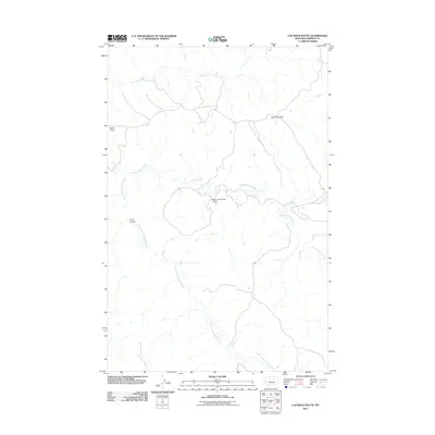
2011 Map of Cap Rock Butte
USGS Topo · Published 2011About this map
Nancy Russell Creek and its tributary, Little Nancy Russell Creek, weave through this section of Garfield County, defining a landscape shaped by intermittent water and high-plains topography. This 2011 survey illustrates the rural infrastructure of central Montana, centered on the Shawver Number 1 Dam and its associated reservoir. The terrain is marked by distinctive elevations such as Cap Rock Butte and Baker Point, while the presence of H Cross Spring suggests the vital importance of natural water sources for ranching in this arid environment. The map also traces the winding path of Curry Coulee and several other drainages including Indian Creek and Wolf Creek, providing a detailed look at the drainage patterns and remote access roads that support the region's agricultural use.
Find a feature on this map
9 named features on this map. Tap any name to fly to it.
Don’t see what you’re looking for? This feature index may not catch every label — zoom into the map to look around manually.
Map Details
Editions of this 2011 Cap Rock Butte Map
This is the sole edition of this map. No revisions or reprints were ever made.
Other maps of this area

1954 · Jordan
USGS Topo · 1:250,000

1956 · Jordan
USGS Topo · 1:250,000

1958 · Jordan
USGS Topo · 1:250,000

1964 · Jordan
USGS Topo · 1:250,000

1965 · Germaine Coulee East
USGS Topo · 1:24,000

1965 · Spring Creek School
USGS Topo · 1:24,000

1965 · Lost Creek
USGS Topo · 1:24,000

1965 · Cap Rock Butte
USGS Topo · 1:24,000

1965 · Pine Grove School
USGS Topo · 1:24,000
1965 · Mickey Butte
USGS Topo · 1:24,000