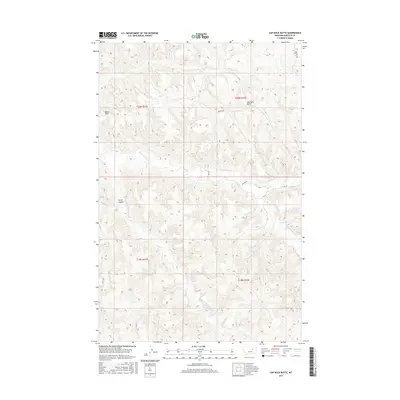
2017 Map of Cap Rock Butte
USGS Topo · Published 2017About this map
Cap Rock Butte rises above the drainage networks of north-central Montana, where the Garfield County landscape is defined by its network of named coulees and creeks. This 2017 survey shows a land shaped by water and wind, marked by prominent landmarks like Baker Point and the winding course of Nancy Russell Cr. The presence of H Cross Spring in the southern portion of the quadrangle highlights the critical importance of reliable water sources in this high-plains environment. A sparse network of roads, including Brusett Rd and Boxcar Rd, provides the primary access through the townships, while terrain features like Curry Coulee and Wolf Cr dominate the topography. This map effectively documents the contemporary cattle-country infrastructure, where township and range boundaries intersect with a hydrological system comprising Little Nancy Russell Cr and Indian Cr.
Find a feature on this map
15 named features on this map. Tap any name to fly to it.
Don’t see what you’re looking for? This feature index may not catch every label — zoom into the map to look around manually.
Map Details
Editions of this 2017 Cap Rock Butte Map
This is the sole edition of this map. No revisions or reprints were ever made.
Other maps of this area

1954 · Jordan
USGS Topo · 1:250,000

1956 · Jordan
USGS Topo · 1:250,000

1958 · Jordan
USGS Topo · 1:250,000

1964 · Jordan
USGS Topo · 1:250,000

1965 · Germaine Coulee East
USGS Topo · 1:24,000

1965 · Spring Creek School
USGS Topo · 1:24,000

1965 · Lost Creek
USGS Topo · 1:24,000

1965 · Cap Rock Butte
USGS Topo · 1:24,000

1965 · Pine Grove School
USGS Topo · 1:24,000
1965 · Mickey Butte
USGS Topo · 1:24,000