
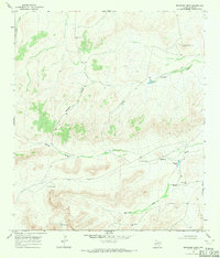
1968 Map of Cap Rock Butte
USGS Topo · Published 1971About this map
Skevington Ranch sits at the heart of this high-desert landscape in the late 1960s, a period when remote West Texas ranching relied on essential water infrastructure like the Red Windmill and various unnamed water tanks. The terrain is defined by dramatic elevation changes, from the level expanse of the W B Flats to the prominent rising profile of Cap Rock Butte. Natural drainage patterns like Big Canyon, Red Mill Draw, and Downie Draw carve through the plateau, illustrating the erosive forces at work in this arid environment. A solitary Landing Strip near the ranch underscores the vast distances of the region, while the boundary between Pecos and Brewster counties runs across the southern portion of the sheet, providing a precise reference for local land records and property history.
Find a feature on this map
10 named features on this map. Tap any name to fly to it.
Don’t see what you’re looking for? This feature index may not catch every label — zoom into the map to look around manually.
Map Details
Editions of this 1968 Cap Rock Butte Map
This is the sole edition of this map. No revisions or reprints were ever made.
Other maps of this area

1920 · Longfellow
USGS Topo · 1:125,000

1954 · Fort Stockton
USGS Topo · 1:250,000

1958 · Fort Stockton
USGS Topo · 1:250,000

1968 · Housetop Mountains
USGS Topo · 1:24,000

1968 · F C Ranch
USGS Topo · 1:24,000

1968 · Marathon Gap
USGS Topo · 1:24,000

1968 · Longfellow
USGS Topo · 1:24,000

1968 · Ebers Camp
USGS Topo · 1:24,000

1968 · Dimple Hills
USGS Topo · 1:24,000
1968 · Reininger Draw
USGS Topo · 1:24,000