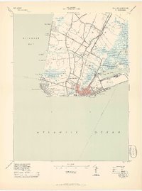
1944 Map of Cape May
USGS Topo · Published 1944About this map
Cape May stands at the strategic tip of New Jersey as a wartime landscape of coastal defense and transit at the peak of the 1940s. The southern peninsula is anchored by the Cape May Coast Artillery Reserve and the Cape May LH, reflecting the area's importance for maritime security between the Atlantic Ocean and Delaware Bay. The Cape May Canal cuts through the marshes, fundamentally altering the local hydrology near West Cape May and North Cape May. Transport is dominated by the complex network of the Reading Seashore Lines and Pennsylvania Reading Seashore Lines, which funnel into Harbor Branch Junction. Beyond the developed resort areas, the map reveals traditional landings like Schellenger Ldg and Weeks Ldg, along with established landmarks like the Tabernacle and Pilgrim Ch.
Find a feature on this map
78 named features on this map. Tap any name to fly to it.
Don’t see what you’re looking for? This feature index may not catch every label — zoom into the map to look around manually.
Map Details
Editions of this 1944 Cape May Map
2 editions found
Other maps of this area

1888 · Cape May
USGS Topo · 1:62,500

1888 · Dennisville
USGS Topo · 1:62,500

1890 · Maurice Cove
USGS Topo · 1:62,500

1891 · Maurice Cove
USGS Topo · 1:62,500

1893 · Cape May
USGS Topo · 1:62,500

1894 · Dennisville
USGS Topo · 1:62,500

1898 · Cape May
USGS Topo · 1:62,500

1899 · Vineland
USGS Topo · 1:125,000

1918 · Cape Henlopen
USGS Topo · 1:62,500

1918 · Cape May
USGS Topo · 1:62,500