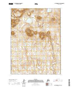
2020 Map of Cape Mendenhall D-4 NE
USGS Topo · Published 2020About this map
Nunivak Island presents a fascinating volcanic landscape on this remote section of the Bethel Census Area. The topography is dominated by the Ibikwit Lava Bed, a clear indication of the region's geological activity. This terrain is marked by a network of small, scattered ponds and wetlands typical of the Alaskan tundra, centered around the larger Karon Lake. The Duchikmiut River winds through the eastern portion of the sheet, serving as a primary hydrologic feature in an area otherwise characterized by interior drainage and seasonal meltwater. The lack of infrastructure or permanent settlements underscores the isolation of this part of the island, where natural landforms and township boundaries like t2s r99w provide the only points of orientation. This record is essential for understanding the geomorphology of the island's interior before changing climate patterns further alter the delicate permafrost and drainage systems.
Find a feature on this map
8 named features on this map. Tap any name to fly to it.
Don’t see what you’re looking for? This feature index may not catch every label — zoom into the map to look around manually.
Map Details
Editions of this 2020 Cape Mendenhall D-4 NE Map
This is the sole edition of this map. No revisions or reprints were ever made.
Other maps of this area

1951 · Cape Mendenhall
USGS Topo · 1:250,000

1951 · Nunivak Island
USGS Topo · 1:250,000

1952 · Cape Mendenhall D-4
USGS Topo · 1:63,360

1952 · Cape Mendenhall D-3
USGS Topo · 1:63,360

1952 · Nunivak Island A-4
USGS Topo · 1:63,360

1952 · Cape Mendenhall
USGS Topo · 1:250,000

1952 · Nunivak Island A-3
USGS Topo · 1:63,360

1954 · Nunivak Island
USGS Topo · 1:250,000

1958 · Nunivak Island
USGS Topo · 1:250,000

1964 · Nunivak Island
USGS Topo · 1:250,000