1952 Map of Cape Mendenhall D-4
USGS Topo · Published 1952About this map
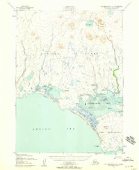
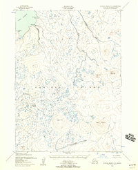
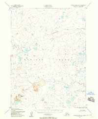
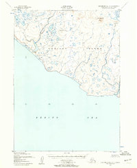
Nunivak Island is revealed in this early 1950s study as a seasonal landscape defined by its indigenous coastal activity. This portion of the Nunivak National Wildlife Refuge showcases a string of seasonal settlements along the southern shore, including Mechakamiut, Chikungamiut, and Duchikmiut. These camps are situated where the tundra meets the Bering Sea, often positioned near the mouths of freshwater sources like the Binajoakamiut River or along the tidal flats of Duchikthluk Bay.
Find a feature on this map
23 named features on this map. Tap any name to fly to it.
Don’t see what you’re looking for? This feature index may not catch every label — zoom into the map to look around manually.
Map Details
Editions of this 1952 Cape Mendenhall D-4 Map
2 editions found

Other maps of this area
1951 · Cape Mendenhall
USGS Topo · 1:250,000

1951 · Nunivak Island
USGS Topo · 1:250,000
1952 · Cape Mendenhall D-3
USGS Topo · 1:63,360

1952 · Nunivak Island A-4
USGS Topo · 1:63,360
1952 · Cape Mendenhall
USGS Topo · 1:250,000
1952 · Nunivak Island A-5
USGS Topo · 1:63,360
1952 · Nunivak Island A-3
USGS Topo · 1:63,360
1952 · Cape Mendenhall D-5
USGS Topo · 1:63,360
1954 · Nunivak Island
USGS Topo · 1:250,000

1958 · Nunivak Island
USGS Topo · 1:250,000