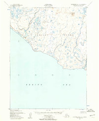
1952 Map of Cape Mendenhall D-5
USGS Topo · Published 1958About this map
Nunivak Island is documented here during the early 1950s, a period when the entire landmass was managed within the Nunivak National Wildlife Refuge. The landscape is defined by its coastal hydrology and seasonal human presence, featuring the seasonal settlement at Chakwakamiut situated near the mouth of the Chakwakamiut River. Further south along the Bering Sea coastline, the map identifies the site of Binajoaksmiut, noted as an abandoned location near the Binajoaksmiut R. Interior features include Jayalik Hill and Jayalik Lake, providing a clear record of the island's drainage patterns and topographic landmarks like Binat-Ingrat Hill before significant modernization. The coastal periphery is marked by natural transitions such as Dunes and Boulder Beach, illustrating the intersection of volcanic terrain and the sea in the Alaska-Second Judicial Division.
Find a feature on this map
13 named features on this map. Tap any name to fly to it.
Don’t see what you’re looking for? This feature index may not catch every label — zoom into the map to look around manually.
Map Details
Editions of this 1952 Cape Mendenhall D-5 Map
3 editions found
Other maps of this area

1951 · Cape Mendenhall
USGS Topo · 1:250,000

1951 · Nunivak Island
USGS Topo · 1:250,000

1952 · Cape Mendenhall D-4
USGS Topo · 1:63,360

1952 · Nunivak Island A-4
USGS Topo · 1:63,360

1952 · Cape Mendenhall
USGS Topo · 1:250,000

1952 · Cape Mendenhall D-6
USGS Topo · 1:63,360

1952 · Nunivak Island A-6
USGS Topo · 1:63,360

1952 · Nunivak Island A-5
USGS Topo · 1:63,360

1954 · Nunivak Island
USGS Topo · 1:250,000

1958 · Nunivak Island
USGS Topo · 1:250,000